Scientists Confirm Fulford’s Story Of Nuclear Attack On Washington’s Underground Sanctuary
Posted on Pakalert on September 25, 2011Hi Tap,
The Aquino paper on HAARP appeared in July, which means that the scientists are now onto HAARP.
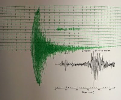
Seismology charts are now revealing that the 5.8 magnitude tremor that rattled the entire East Coast including Washington DC was not a natural earthquake but an earthquake that resulted from an underground nuclear detonation. The image above is a seismograph from Washington and Lee University, (similar one found on www2.tricities.com website) about 85 miles southwest of the earthquake’s epicenter in Mineral. The green lines indicates the tremor that was felt in Washington DC which caused damaged to the Washington Memorial and the Washington National Cathedral. The black lines is a transparent overlay of a seismograph from a pdf file from Virginia Division Mineral Resources on Earthquakes.

- This shows the Washington nuclear detonation in green compared to an earthquake in black.
The unheard of occurred in Washington DC this afternoon August 23, 2011. A shallow 5.8 magnitude earthquake shook Washington DC this afternoon. The epicenter was 84 miles SW of Washington DC. Early in the day another shallow 5.3 magnitude earthquake shook Denver Colorado. Both earthquakes occurred just south of key U.S. government centers. Washington DC is obvious and Denver is now home to the CIA domestic operations which is responsible for operations and recruitment in the United States. The CIA recently moved there from the CIA’s Langley Virginia headquarters.
An earthquake has never been felt in Washing DC before. Denver is familiar with earthquakes. Is it just a coincidence that ABC news anchors warned of possible terrorist attacks against the United States before the 10th anniversary of 9/11?
The U.S. Geological Survey said the Virginia earthquake was 3.7 miles deep. Shaking was felt at the White House and all over the East Coast, as far south as Chapel Hill, N.C. Parts of the Pentagon, White House and Capitol were evacuated. The quake was in Mineral, Va., in Louisa County.
The magnitude 5.3 Colorado quake hit nine miles southwest of Trinidad, or 180 miles south of Denver, according to the U.S. Geological Survey’s National Earthquake Information Center in Golden. It had an estimated depth of 2.5 miles (4 kilometers) and was felt in a relatively large area of southern Colorado and northern New Mexico.
How do these earthquakes compare to a nuclear detonation, as warned by ABC (refer to Featured Videos 3 and 5 ) . A 6.0 magnitude earthquake is equivalent to the nuclear detonation by the U.S. against Hiroshima, Japan.
presscore.ca clearly has high-powered connections.
The bankers are in serious trouble.


No hay comentarios:
Publicar un comentario